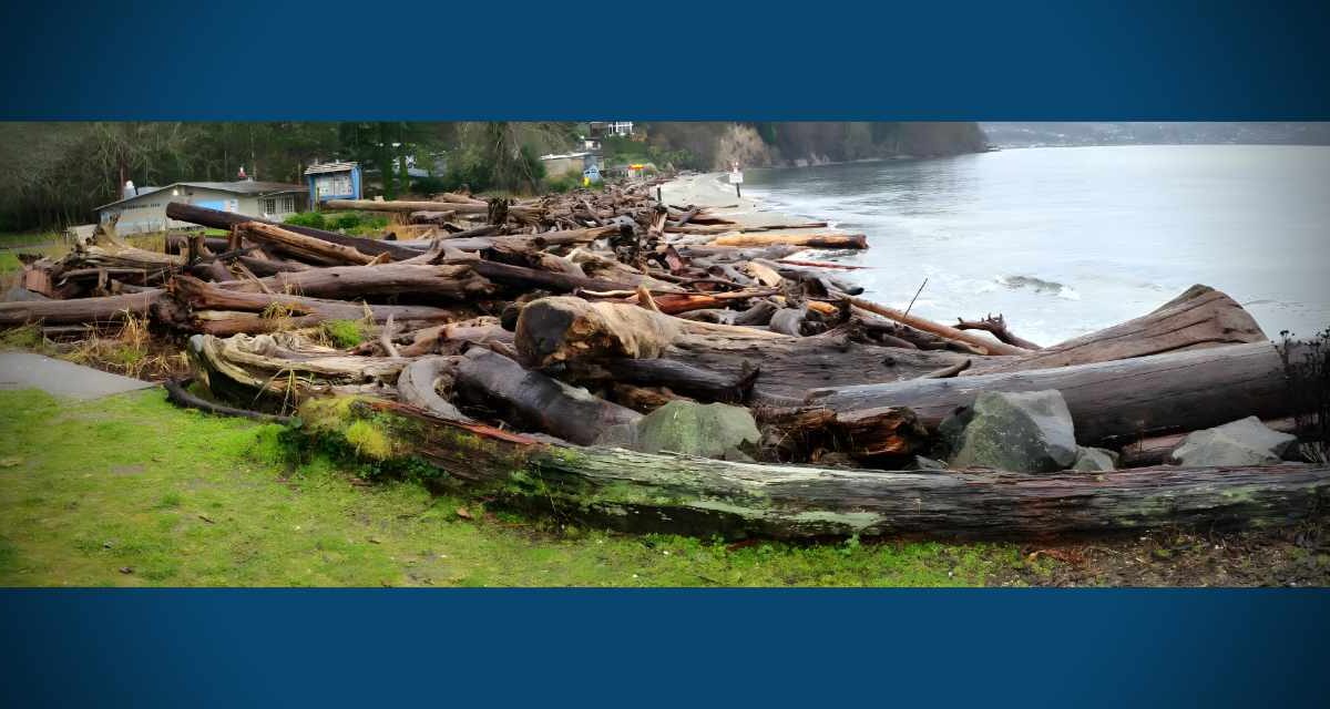
Quantcast

We’re pretty sure that the last time a tsunami hit the northwest coast of the U.S. was in 1964, shortly after a major earthquake struck Alaska; far as we know, it damaged some places on the Oregon coast, including Cannon Beach.

Saturday morning (Feb. 27th), imagine our surprise when we saw an “Advisory” posted in our Weather Widget in the right sidebar. Clicking on it revealed that yes, a “Tsunami Advisory” had been issued for the northern and central Washington coast after a huge, 8.8 quake hit Chile´.

We don’t think this is cause for panic in the Puget Sound region, but we wanted to share this info because, well, who knows – maybe a small, tsunami-based wave will hit the shorelines near Des Moines late this afternoon? Maybe not?

The advisory warns that, if indeed a tsunami wave makes it up the coast, takes a right turn through the Strait of Juan de Fuca, makes another right and heads down through the upper islands of Puget Sound…when (and if) it hits Pier 48 in Seattle it’s predicted to be .13 feet high, which, according to our rudimentary math skills, equals a measly 1.56 inches high.

According to this NOAA website, the predicted time for this wave to strike Seattle is 1641 PST – for us non-military types, that’s 4:41pm Saturday afternoon.

If you happen to have a video camera and a lot of free time this afternoon, why not hang out near Des Moines’ waterfront around 4:30-5pm and see if you can videotape a 1.56 inch wave barreling down from the north? We’d love to post it – please email us if you do!

And if you know anyone who lives on the coast, or in Hawaii, please make sure they’re aware of this advisory, as it could be very serious in those areas.

According to the National Weather Service:

Persons in tsunami advisory areas should move out of the water… off the beach and out of harbors and marinas.

Tsunami advisories mean that a tsunami capable of producing strong currents or waves dangerous to persons in or very near water is imminent or expected. Significant widespread inundation is not expected for areas in an advisory. Tsunamis are a series of waves potentially dangerous several hours after initial arrival time. Estimated times of initial wave arrival for selected sites in the advisory are provided below.

Here’s the “Tsunami Advisory” language as posted at 9:18am:

Tsunami Advisory

Statement as of 9:18 AM PST on February 27, 2010

… A tsunami advisory remains in effect for the northern and central Washington coast…

A tsunami advisory remains in effect for the northern and central Washington coast.

There is no Tsunami Watch or warning in effect for the Washington coast. Repeat… there is no Tsunami Watch or warning in effect.

A powerful 8.8 magnitude earthquake occurred at 1034 PM PDT Friday near the central coast of chile. It has generated a tsunami wave… which is now spreading out across the Pacific Ocean.

The first tsunami waves are expected to reach the Washington coast between 250 PM and 310 PM PST this afternoon. The following are the
estimated arrival times of the first waves.

  • Seaside or… … ..246 PM PST
  • Westport WA… … .257 PM PST
  • Neah Bay WA… … .307 PM PST

The largest tsunami waves are expected two hours after the first arrival.

The waves are not expected to be large enough to cause coastal flooding along the Washington coast. However… some coastal areas could experience dangerous currents and surges in harbors and bays. Forecast tsunami wave amplitudes follow.

  • Long Beach WA… ..0.46 ft
  • Westport… … … .0.78 ft
  • Moclips… … … ..1.27 ft
  • Neah Bay… … … .0.65 ft
  • Port Angeles… … 0.33 ft
  • Bellingham… … ..0.46 ft
  • Everett… … … ..0.13 ft
  • Seattle-pier 48… 0.13 ft

The minimum wave height for a tsunami advisory on the Washington coast is 6 inches or 15 centimeters.

The initial wave will not be the largest. Coastal residents are advised to stay out of the water… off the beach… and away from harbors and marinas. Wave heights and currents are amplified by irregular shoreline and are difficult to predict. The tsunami may not be visible among the common ocean surf… yet tide gages will likely report some fluctuations.

Mariners in water deeper than 600 feet should not be affected by a tsunami.

Repeat… no Tsunami Watch or warning is in effect for the northern and central Washington coast.

And just ‘cuz we found it and we love science, here’s a pretty cool simulation video of what might happen if a tsunami hit Elliott Bay:

[youtube]http://www.youtube.com/watch?v=n2AGlhuCQ-A[/youtube]

The National Weather Service issued an unusual Advisory Monday (Jan. 18th) – this one for a “minor tidal overflow” that will be in effect for Puget Sound Tuesday morning and possibly again Wednesday morning.

According to the report, “very high astronomical tides combined with lower than normal atmospheric pressures” as well as high winds may cause some flooding.

So, if you live near the shoreline and your street/yard/area has a tendency to flood, you might want to put out some sandbags just in case.

Here’s the actual advisory:

… Coastal Flood Advisory for minor tidal overflow is in effect for Puget Sound and the north interior from 5 am to 11 am PST Tuesday…

The National Weather Service in Seattle has issued a coastal Flood Advisory for minor tidal overflow from Puget Sound to the north interior… which is in effect from 5 am to 11 am PST Tuesday.

Minor tidal overflow may occur along some of the shorelines and nearby low-lying areas around Puget Sound and the north interior Tuesday morning… around the time of high tide. Minor tidal overflow is caused by very high astronomical tides combined with lower than normal atmospheric pressures. The Table below shows time of high tide for areas around Puget Sound… along with the normal tide table value and the expected total tide.

Time of tide table expected expected location high tide value anomaly total tide

  • Seattle 7:30 am 12.2 ft 1.6 ft 13.8 ft
  • Port Townsend 7:06 am 9.1 ft 1.8 ft 10.9 ft
  • Bellingham 8:12 am 9.6 ft 1.9 ft 11.5 ft

Minor tidal overflow problems usually begin at 13.5 feet around Seattle and 11.5 feet around Bellingham… and the current forecasts for those areas just meet or exceed those levels. In addition… the atmospheric pressure could be a little lower than forecast… and local winds may cause water to pile up along shorelines more than expected… possibly higher than the expected total tide values. Southeast winds 20 to 30 knots are forecast over the northern inland waters Tuesday morning as another deep low pressure system moves northward offshore. Winds over the waters of Puget Sound are expected to be south 10 to 20 knots Tuesday morning.

Another very high astronomical tide will occur Wednesday morning. The forecast tides for Wednesday morning are slightly lower than for Tuesday… but computer model forecasts indicate the anomaly will still be large enough so that minor tidal overflow problems remain a possibility.

Precautionary/preparedness actions…

Minor tidal over flow can cause local flooding along shorelines and nearby low-lying areas.

Highline’s Marine Science & Technology 
(MaST) Center’s fall speaker series continues with the next session on Dec. 5th, from Noon to 1pm, featuring New Tools to Inform Nearshore Restoration with Doug Meyers.

Meyers, director of science for People for Puget Sound, will share the results of a comprehensive analysis for the restoration of Puget Sound’s nearshore ecosystem. This 10-year, multi-agency investigation combined cutting edge physical and social science to identify spatially explicit disruptions to natural ecological processes in the last 150 years.

Here are the details:

WHAT: MaST’s “Science on the Sound” speaker series

WHEN:  Saturday, Dec. 5th, from Noon to 1 p.m.

WHERE:  Highline Community College’s Marine Science & Technology 
(MaST) Center, which is located on Redondo Beach in Des Moines; address: 28203 Redondo Beach Drive S., Des Moines, WA 98198.

COST: Free

INFO: Science on the Sound is a semimonthly seminar that features experts discussing issues pertinent to the Puget Sound and the region.
Upcoming speakers for Science on the Sound include:

  • Nov. 21st: Introduction to Footloose Disabled Sailing; Bob Ewing, one of the original founders of the Footloose Sailing Association, shares amazing success stories of people with disabilities who discover the wonders of sailing. Ewing encourages people to join the sport to help them move beyond disability and into empowerment.
  • Dec. 5th: New Tools to Inform Nearshore Restoration; Doug Meyers, director of science for People for Puget Sound, shares the results of a comprehensive analysis for the restoration of Puget Sound’s nearshore ecosystem. This 10-year, multi-agency investigation combined cutting edge physical and social science to identify spatially explicit disruptions to natural ecological processes in the last 150 years.

For more information, visit the MaST website here.

The National Weather Service issued a “Special Weather Statement” at 4:30pm Thursday (Nov. 12th), warning of a “vigorous cold front” hitting the area Friday morning, bringing rain, wind and snow to the mountains.

Could this be the first breath of ol’ man winter?

Here’s the statement:

… Active weather day expected Friday…

A vigorous cold front will pass southeast across western Washington Friday morning… bringing Rain… Mountain snows… locally windy conditions and possibly snow showers to parts of The Lowlands.

South winds in advance of the front will increase late tonight into early Friday morning… mainly along the coast and parts of the northwest interior including the Admiralty Inlet region. Wind speeds in those areas are expected to reach 20 to 30 mph with a few gusts to 45 mph… mainly in and around the Island County area. After the front passes… winds will become west to southwest down the Strait of Juan de Fuca and across the northwest interior before diminishing through the afternoon. While below Wind Advisory criteria… wind of this strength could blow down a few tree limbs here and there with isolated power outages.

Colder air will surge in behind the front and lower already low snow levels across the region. During the morning hours ahead of the front the snow level will be around 1500 to 2000 feet. The snow level will then gradually drop through the day to around 500 feet by evening. This means some of the highest hills around the region could see a few snow showers late Friday into Friday evening. However… outside of the mountains or the immediate Cascade foothills… little to no snow accumulation is expected.

Dry and tranquil weather will return to the region late Friday night into Saturday.

Wednesday morning (Nov. 4th), the Port of Seattle and Alaska Airlines conducted a full-scale snow removal and anti-icing exercise to prepare for the upcoming winter season.

Photographer Michael Brunk risked his life on Sea-Tac Airport’s tarmac to get these photos:

Click to View Michael Brunk’s Photo Slideshow

During the 2008-2009 season, SeaTac Airport experienced just over 23 inches of snow, compared to an average of 12 inches. While airport operations continued during the higher than normal snowfall, some improvements are being made for the 2009-2010 season.

Alaska Airlines has added eight new de-icing trucks to their fleet and three “nurse trucks” that will shuttle fluid from storage tanks to the new de-icing trucks. The new de-icing trucks feature an enclosed operator cockpit that allows them to operate safely around aircraft while the aircraft engines are still running. This feature coupled with new procedures will allow Alaska Airlines to de-ice an aircraft much more quickly and efficiently using central de-icing pads that will use a “car wash” model.

The Port of Seattle — which is responsible for clearing snow and ice from runways, taxiways and the ramp areas — has also taken delivery of several new vehicles that were already on order prior to last year’s unusual snow event. Using several snow plows followed by snow brush trucks one runway can be plowed and cleared in 30-45 minutes.

The National Weather Service issued a “Special Weather Statement” Tuesday, Nov. 3rd at 4:57pm, warning of “very strong” winds and rain hitting the area Thursday (Nov. 5th) with gusts possibly as high as 50mph.

Here’s the warning in all its glory:

Statement as of 4:57 PM PST on November 03, 2009

… Windy conditions for the mountains… coast… and northern interior Thursday…

A strong Pacific frontal system will impact western Washington on Thursday. Breezy southeasterly winds on Wednesday night will become south-southwest on Thursday for the north interior and coast increasing to 20 to 30 mph with gust as high as 50 mph.

Winds just above the surface will be very strong on Thursday. Ridgetop winds for the Olympics and lower south facing slopes will range from 45 to 65 mph with higher gusts possible. Ridgetop winds along the southern slopes of the Cascades will also be windy… with sustained winds up to 50 mph possible. The strong winds will also be accompanied by heavy rains… combining for dangerous conditions in the mountains.

So…considered yourself warned – hold on to your hats and batten down your boats Des Moinesians!

The National Weather Service has issued a “Special Weather Statement” alerting us all that, despite the recent sunny and mild weather, the rain is a-comin’ back, starting Tuesday (Oct. 13th), so be sure to take heed an move all that crap in your yard and driveway back inside.

Here’s the statement, which was published at 4:44pm Sunday Oct. 11th:

Statement as of 4:44 PM PDT on October 11, 2009

… A series of Pacific storms will affect western Washington this week…

Columbus day will be a transition day from the recent cool and dry spell to an active… wet pattern. Look for a series of Pacific storms to affect the area starting Tuesday. The Tuesday system is expected to bring windy conditions to the coast and Cascade foothills as well as precipitation to the entire area. Chilly…east winds in the Cascade passes will mean that the precipitation will begin as snow or a rain and snow mix. However… significant snowfall amounts are unlikely.

Unsettled… wet conditions will persist on Wednesday as the region remains under the influence of a large area of low pressure over
the eastern Pacific. A much wetter system may affect the area during the latter part of the week.

Monitor forecasts from the National Weather Service in Seattle for updates on these upcoming events.

(Photo by Michael Brunk)

by Dr. Leslie Kasper, DVM
Companion Animal Medical Center

Boy it’s hot out! Ninety-plus degree weather and no real rainfall in months; Des Moines residents haven’t seen weather like this for some time! But I guess now they understand the real meaning of “The Dog Days of Summer.”

I mean really, you think you got it bad?! Don’t forget about us – imagine wearing a fur coat and not being able to sweat other than through the pads of your feet (unless they are hairy too) and by panting! Yuck, Dry Mouth! So just as a kindly reminder from some of your fuzzy four-legged friends, here are some tips to help make keep us cool and comfortable too!

Cars + Pets = Death!
Think I’m being dramatic? Hundreds of pets die every year from being left in cars during summer heat. Yes, I know it’s just a quick errand and you left the windows cracked or even down, but in 80+ degree heat outside, the inside of a car can easily reach over 100 degrees in about five minutes. Best course of action is to just leave me at home! Really, you will only be gone a few minutes…

Shade or Shelter
If some of your four-legged friends spend a majority of their time outside during the day, make sure they have an adequate amount of shade to protect themselves. Doghouses can be helpful, but like your house or car, if it’s in the sun all day they can hold heat and provide little comfort. If the roof is detachable try lifting it up slightly or setting it off kilter to allow for airflow and heat escape. Having a second shelter or shaded area allows for options as the day and temperatures progress. If your pet has a light skin colored nose or ears (areas with little to no hair) a bit of sunscreen may be warranted as well.

Fresh water at all times!
Inside or out, all pets need access to fresh clean water. If possible when outside keep it in the shade, then it is bearable to drink and doesn’t evaporate quite as fast. Multiple bowls may be needed as we will go through more water than usual. But even inside, with all the fans and a/c going, the air becomes dry, and a good drink would feel great on that panting tongue. And ice cubes make fun toys!

Oh, and on the subject of mouths…
Don’t be surprised if the appetite falls off a bit! Sometimes it just doesn’t sound appealing to eat in this heat. Oh, and of course, sometimes heat can cause imbalances in the intestines, so soft stools can occur also!

Emergency Situations
Okay, we all know you are great pet-parents, but sometimes it’s just too hot! If you notice any of these symptoms, please call my veterinarian right away for evaluation or advice:

  • Difficulty breathing, especially in cats or dogs with short noses (like pugs, pekes, bull dogs, and others)
  • Pale gums, nose, eyes, or inner ears which are normally pink.
  • Vomiting, diarrhea, or lack of food/water intake
  • Shaking, seizures, or unresponsiveness when stimulated.

Okay, now go out and be safe!

Sincerely,
Rover and Tiger

(Courtesy of WLB Advertiser Companion Animal Medical Center, 206-878-0405)

The City of Des Moines Monday opened a free “Cooling Center” for all residents at the Activity (Senior) Center, located at 2045 South 216th Street, through Thursday from 11am to 9pm.

The shelter accommodations are minimal (but we believe there’s air conditioning). Water will be provided at the shelters but no food will be available. Small pets in carriers will be allowed but the owner is responsible to provide food, water and bowls for the animals.

There are other numerous places around with air conditioning that you can take advantage of; here’s a list (more listed at the King County website):

DES MOINES:

  • City Cooling Shelter at the Activity Center (Senior Center)
    2045 S. 216th Street, Des Moines
    Open for Des Moines and Normandy Park residents, Monday-Thursday this week from 11:00am to 9:00pm. The shelter accommodations are minimal, water will be provided at the shelters but no food will be available. Small pets in carriers will be allowed but the owner is responsible to provide food, water and bowls for the animals. Pets will be required to remain in their carriers will inside the shelter. An information phone number with recorded information has been set up at (206) 870-6719.
  • King County Library – Des Moines branch
    21620 11th Avenue South
    Des Moines 98198
    Phone: 206-824-6066
  • King County Library – Woodmont branch
    26809 Pacific Highway South
    Des Moines 98198
    Phone: 253-839-0121
  • Beaches! Puget Sound!
    Nothing beats the heat better than being in the cold natural waters around us. Just use common sense, and be aware that the waters are still cold enough to cause hypothermia. We recommend just wading or dipping ones toes in whilst eating an ice cream cone.
  • Mt. Rainier Pool
    22722 19th Ave South
    Des Moines 98198
    Phone: (206) 824-4722
    Fees are $3.25 per hour (seniors) and up

BURIEN:

  • King County Library branch on SW 152nd and 4th SW (as well as any KCLS branch in the area)
  • Any bar/restaurant/coffee shop that doesn’t have its windows open (your first clue to A/C use)
  • Stores – stay cool by going from store to store around town!
  • The myriad of beaches around town, especially Seahurst Park Beach

TUKWILA:

  • Tukwila Community Center
    12424 42nd Avenue South
    6:15am. – 9pm (Monday – Thursday)
    Phone: 206-768-2822
  • Tukwila Aquatic Playground
    12424 42nd Ave South
    Tukwila, WA 98168
    Website: http://www.ci.tukwila.wa.us/recreation/recbrochure.html
  • Southcenter, where “it’s always a beautiful day” (and a cool one this week)
  • Tukwila Pond (go ahead and jump in, it’s not just a swamp…)

SEATAC:

  • SeaTac Community Center
    13735 24th Avenue South
    SeaTac, Washington 98168
    Phone: 206.973.4680
  • Angle Lake
    Pacific Hwy South at S. 195yh
    Free swimming in a real lake!

FEDERAL WAY:

  • Federal Way Community Center
    876 S. 333rd Street
    5:30 a.m. – 9:30 p.m. (weekdays)
    7:00 a.m. – 6:00 p.m. (Saturday)
    10:00 a.m. – 6:00 p.m. (Sunday)
    Phone: 253-832-6900
  • Wild Waves Water Park (cost involved)
    36201 Enchanted Pkwy
    Federal Way
    Phone: (253) 925-8000

AUBURN:

  • Auburn Senior Center
    808 9th Street SE
    8 a.m. to 9 p.m., Monday to Thursday
    Crated/caged pets welcome.Some pet cages available for those who don’t have them.
    Phone: 253-931-3016
  • Auburn Library
    1102 Auburn Way S
    10:00 a.m. – 9:00 p.m. (Monday – Thursday)
    Phone: 253-931-3018
  • Auburn City Hall
    25 W Main
    8 a.m. to 9 p.m., Monday to Thursday
    Crated/caged pets welcome. Some pet cages available for those who don’t have them.
    Phone: (253) 931-3033

For all you weather nerds out there, here’s a link to a new UW website called “probcast.com” that will do customized forecasts based on zip codes; we did one for 98198, and the predicted high for Wed. is now 103!

An Excessive Heat Warning will remain in effect until 6pm Thursday, July 30th; this means that a period of dangerously hot temperatures is expected which can lead to heat related illnesses. Anyone can be overcome by extreme heat, but some people are at higher risk than others. They include the elderly, the very young, and people with mental illness and chronic diseases

Signs and symptoms of heat related illness may vary but can include:

  • heavy sweating
  • paleness
  • muscle cramps
  • tiredness
  • weakness
  • dizziness
  • headache
  • nausea or vomiting
  • fainting

Heat exhaustion can lead to heat stroke, which can cause death or permanent disability unless treated immediately. Symptoms of heat stroke include an extremely high body temperature (above 103°F); red, hot, and dry skin; rapid, strong pulse; nausea, confusion and unconsciousness.

Public Health – Seattle & King County is urging people to take precautions and monitor themselves and others for signs and symptoms of heat related illness and call for medical aid as necessary.

Be sure to drink plenty of fluids and stay in air-conditioned buildings such as public libraries and community centers, malls and movie theaters. Check on relatives and neighbors, particularly those with health issues. Never leave children or pets unattended in a vehicle, even with the windows rolled down.

More hot weather safety tips are available at www.kingcounty.gov/health/BeatTheHeat

Looks like the much-hyped “Hotpocalypse ‘09™!” is finally hitting, with temps forecast to be in the 90s over the next several days, prompting local health officials to issue the following common sense tips:

“Protect yourself and your loved ones from heat exhaustion and heat stroke by following these recommendations:

STAY COOL:

  • Spend more time in air conditioned places. If you don’t have air conditioning, consider visiting a mall, movie theater or other cool public places (ie: Southcenter, where “it’s always a beautiful day”)
  • Go down to the water! Take advantage of this city’s beaches!
  • Cover windows that receive morning or afternoon sun.
  • Dress in lightweight clothing.
  • Check up on your elderly neighbors and relatives.

DRINK LIQUIDS:

  • Drink plenty of water or non-alcoholic beverages.
  • Don’t wait until you’re thirsty to drink.

WHILE OUTSIDE:

  • Limit your direct exposure to the sun.
  • Do not leave infants, children, people with mobility challenges and pets in a parked car, even with the window rolled down.
  • Avoid or reduce strenuous activity.
  • Limit outdoor activity to morning and evening hours.
  • Avoid sunburn by using a sunscreen with a high SPF (sun protection factor) rating.

Check with your physician if you are concerned about heat and the specific medications you are taking. Certain medications may increase sensitivity to the heat. Do not take salt tablets unless directed to by a physician.

Heat can lead to serious medical problems, particularly for older adults, young children, people with chronic illness, and people with weight or alcohol problems.

“The danger for heat–related illnesses rises when outside temperatures are very high,” said Dr. David Fleming, Director and Health Officer for Public Health – Seattle & King County. “Fortunately, all of us can prevent heat exhaustion or heat stroke with some simple steps.”

RECOGNIZING HEAT STROKE:

Overheating occurs when people’s bodies are not able to cool themselves quickly enough and can lead to symptoms of heat exhaustion, including muscle cramps, weakness, dizziness, headache, nausea and vomiting. If you notice someone with signs of overheating, move the person to a cooler location, have them rest for a few minutes and slowly drink a cool beverage. Seek medical attention for them immediately if they do not feel better.

In severe instances, people can suffer heat stroke, which can cause can cause death or permanent disability if emergency treatment is not provided. Symptoms of heat stroke include:

  • An extremely high body temperature (above 103°F)
  • Red, hot, and dry skin
  • Rapid, strong pulse
  • Nausea, confusion and unconsciousness

For more tips and resources on staying cool in hot weather, visit www.kingcounty.gov/health/BeatTheHeat.

The National Weather Service issued a “Special Weather Statement” late Thursday afternoon (July 23rd) warning about a heat wave that will begin this weekend and last into next week, with projected highs in the 85-95 degree range.

Here’s the official warning:

… Hot weather beginning this weekend and lasting into next week…

The hottest weather of the year is likely to occur this weekend and early next week. High temperatures will be in the 85 to 95 range. Overnight lows will be in the 60s. All areas of western Washington could be affected.

The first really hot day will be Saturday or Sunday. The hottest days look like Sunday through Tuesday. At this time models predict the hot weather could last into Thursday or beyond.

Unlike many previous hot spells… this one could also affect the coast and other places near the water. Also it is rare to have many hot days in a row in western Washington… but this heat wave could last several days.

Western Washington is having a dry Summer… and no rain is in the forecast for the next week or so. Fire danger will increase during the hot weather. There is also a risk of air stagnation during this period.

The National Weather Service will issue more statements about this event over the coming days.

And according to meteorologist Cliff Mass:

“I took a look at the long-range forecasts and was shocked.

The temperature climbs through the weekend…into the lower 90s on Sunday and mid 90s at least on Monday and Tuesday.

Too far out to be sure now….but be ready for real heat.”

BTW, Cliff also adds that:

“2009 is the driest 20 May-19 Jul period on record using the combined SeaTac/downtown observations”

So…have a great weekend, but stay cool, slathered up, and be sure to check in on elderly neighbors/relatives and drink plenty of water!

The National Weather Service issued a “Special Weather Statement” Sunday afternoon about a strong, windy weather system that’s predicted to hit the area Monday night.

We’re no Cliff Mass, but one thing that struck us was the mention of the pressure in this storm, rated at 980 millibars. As comparison, Hurricane Katrina was rated at 920 mb (lower is stronger), and the Inauguration Day storm of 1993 was rated between 972-980 mb (for a great read on northwest storm systems, with info on pressures, click here).

While it’s a powerful system, since the storm will weaken as it pushes inland, wind speeds are predicted to be between 20-35 mph, with gusts up to 45. There could be downed trees and power outages though, so you may want to batten down your boat if you’ve got one.

Here’s the statement:

Statement as of 3:51 PM PDT on May 03, 2009

… Very windy conditions are expected to develop in the western Washington lowlands Monday night and continue through Tuesday morning…

A developing storm system in the central Pacific is expected to deepen to around 980 mb as it moves through the Washington offshore waters toward northern Vancouver Island Monday and Monday night. A strong frontal system associated with this low will move through western Washington Monday night.

A storm and frontal system of this magnitude is more typical of late fall or winter than of early may.

At this point it appears that south winds of 20 to 35 mph with gusts to 45 mph will develop Monday night as the front moves through and continue through the early morning hours on Tuesday. Many deciduous trees are now leafing. So winds of this magnitude may break some large branches and possibly topple a few trees.

Local power outages are possible.

It snowed last night, continues in some areas, and as of 6:32am Thursday Feb. 26th here are the latest weather-related school and travel updates:

  • HIGHLINE SCHOOL DISTRICT: 2 HOURS LATE

Updated: 5:42 a.m. February 26, 2009

Highline Public Schools will operate two hours late today. Emergency bus transportation is in effect.

*There will be no breakfast, no morning classes for preschool, kindergarten, ECEAP, or PSSC. Afternoon classes for these programs will be on time.

*Schools will dismiss at regular times.

Snow and power failures can cause disruptions for schools and families. During these difficult times, HIghline Public Schools will do all it can to communicate vital information to parents and students.

Our top priority is student safety!

Here’s the latest from the National Weather Service:

Statement as of 4:35 AM PST on February 26, 2009

… Additional snowfall of an inch or two and freezing temperatures will warrant caution this morning…

Hazardous driving conditions will be the rule across western Washington this morning due to snow that has already fallen… possible accumulations of another inch or two… and freezing temperatures.

Scattered snow showers will continue this morning as the upper level low pressure system over the area moves eastward. Local
additional accumulations of an inch or two are possible. In addition temperatures have fallen below freezing across most of western Washington this morning… so roads and sidewalks will be icy even if they are free of snow.

These conditions will be relatively short lived. Temperatures will climb above freezing by noon today with highs around 40… and most of the area will have partly sunny skies.

For all you commuters out there, here are some live feeds from area webcams:

I-5: SR 516

I-5: S 260th St.

I-5: S 320th St.

I-5: S 200th St.

I-5 at 188th

I-5: S 178th St.

Southcenter

SR 518: SR 99 Interchange South

SeaTac Airport Webcam

I-5/SR 599 Interchange

Hwy 99 at West Marginal Way

Switch to our mobile site